Seddülbahir
Zığındere Sahili (Y2 Sahili)
Zığındere, Gelibolu Yarımadası'nın Seddülbahir kesiminde, yaklaşık olarak kuzeydoğudan güneybatıya doğru uzanıp Ege Denizi’ne dökülen bir akarsudur. Dere yatağı günümüzde kurudur. Derenin denizle buluştuğu ağız kısmındaki sahil çıkarma yapmaya müsait olduğu gibi, sarp yamaçları bulunan dere yatağı da çıkan birlikler için koruma sağlama potansiyeline sahiptir. Bu nedenle 25 Nisan 1915 sabahı Türk (Osmanlı) birlikleri tarafından görece olarak daha iyi korunmaktaydı. (Ancak işgal kuvvetleri bu bölgeye değil, yakınındaki İkiz Koyu’na ve Pınariçi Koyu’na çıkarma yapmıştır.)
İlk çıkarma alanlarından biri olmamakla birlikte, işgal kuvvetleri tarafından ele geçirildikçe bir lojistik üs haline gelmiştir. Ayrıca bu sahil, Zığındere ağzının yaklaşık 350 metre (400 yarda) kuzeyinde infaz edilen iki idama sahne olmuştur. (Chambers, 2015, s.164)
Cape Helles
Gully Beach (Y2 Beach)
Gully Ravine is a stream located in the Cape Helles region of the Gallipoli Peninsula, flowing approximately from northeast to southwest into the Aegean Sea. The streambed is currently dry. The beach at the mouth of the stream is suitable for amphibious landings, while the steep slopes of the streambed offer potential for providing cover for advancing troops. Consequently, on the morning of April 25, 1915, Turkish (Ottoman) forces were relatively better positioned for defense in this area. However, Allied forces chose to land at nearby Ikiz Cove and Pinarici Cove instead.
Although Gully Ravine was not one of the initial landing sites, it became a logistical base as Allied forces advanced and secured the area. Additionally, this beach was the site of two executions carried out approximately 350 meters (400 yards) north of the Gully Ravine river mouth. (Chambers, 2015, p.164)
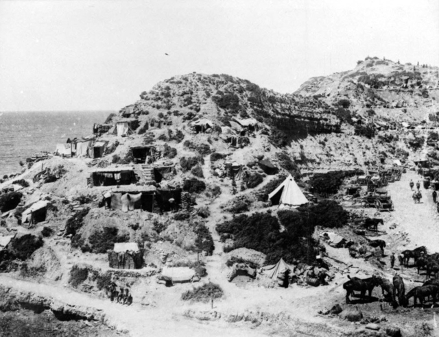
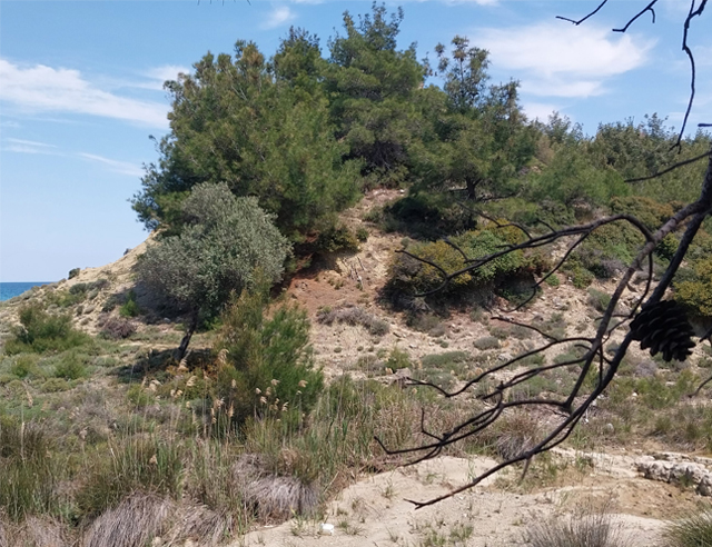
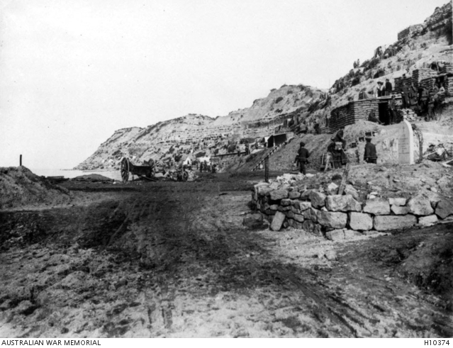
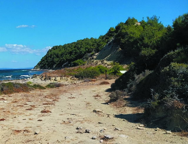
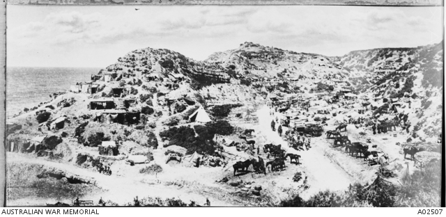
İlk sıradaki iki fotoğrafta, Zığınderenin denize döküldüğü noktadan dere yatağına hemen girişte solda (akarsuyun akış yönüne göre çıkışta, sağda) yer alan bir tepe görünmektedir. Tarihi fotoğraf 1915 yılına aittir. Bugün tarihi fotoğraf ile aynı açıdan bir fotoğraf çekmek, bölgede büyüyen ağaç ve makiler nedeniyle mümkün görünmemektedir.
In the first two photographs, the prominent hill located immediately to the left (or right, depending on the direction of the stream's flow) at the entrance of the streambed is visible. The historical photograph dates back to 1915. Today, capturing a photograph from the same angle as the historical one is challenging due to the growth of trees and shrubs in the area.
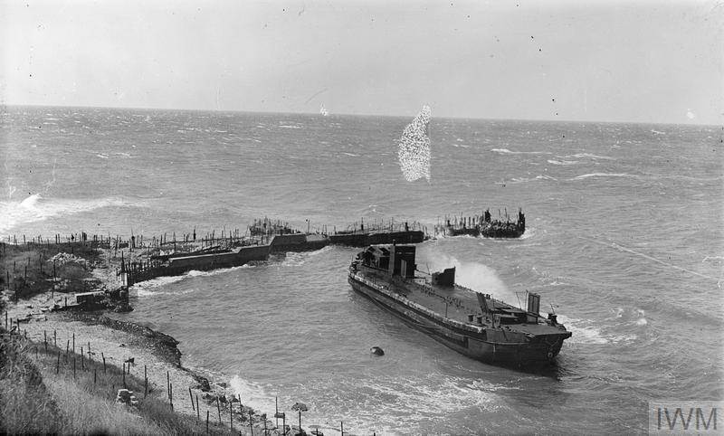
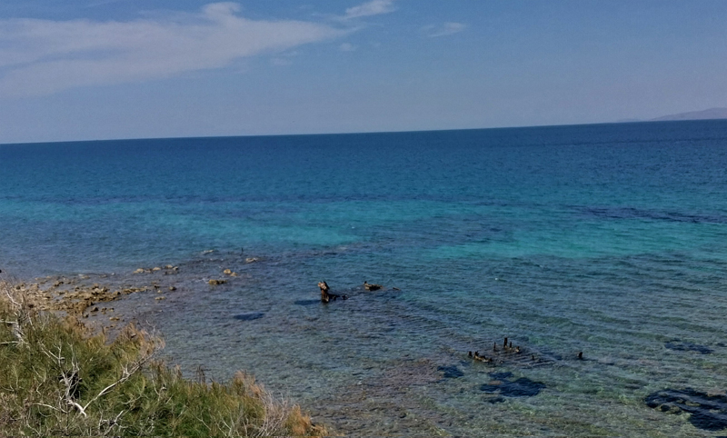
İkinci sıradaki fotoğraflardan tarihi olan (url-1) 1919 yılında çekilmiştir. Fotoğraf, işgal kuvvetlerinin tahliye esnasında Zığındere ağzında terk ettikleri, karaya oturmuş bir mavnayı (layter) göstermektedir. Günümüzde (2025) bu mavnanın kalıntıları halen görülebilmektedir. Benzer şekilde tarihi fotoğrafta görülen iskelenin kalıntıları da halen seçilebilmektedir.
The historical photograph in the second row (url-1) was taken in 1919. It depicts a lighter that was grounded and abandoned by the Allied forces during their evacuation at the mouth of Zığındere. As of 2025, the remnants of this vessel remain visible. Similarly, the remains of the pier shown in the historical photograph can still be discerned today.
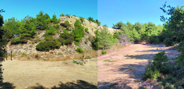
Zığındere'nin denize döküldüğü noktayı yaklaşık olarak güneybatıdan kuzeydoğu istikametine doğru gösteren fotoğraf 1915 yılına aittir.
The photograph, taken in 1915, shows the point where Gully Ravine flows into the sea, looking approximately from the southwest toward the northeast.
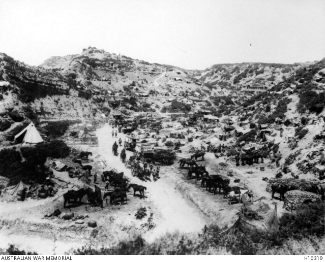
Zığındere Sahili'nden Zığındere'ye girer girmez (yaklaşık 50 - 60 metre sonra) dere yatağı neredeyse 90 derecelik bir açı ile sola (kabaca kuzeye) döner ve yaklaşık 70 - 80 metre kadar düz olarak devam eder. Fotoğraflar bu 70 - 80 metrelik düzlüğü göstermektedir.
Just after entering Gully Ravine from the Gully Beach (approximately 50 – 60 meters in), the stream bed turns almost 90 degrees to the left (roughly north) and continues straight for about 70 – 80 meters. The photographs show this 70 – 80 meter straight section.
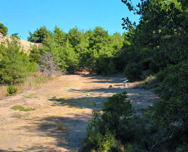
Beşinci sıradaki fotoğraf da, bir önceki ile yakın bir noktadan çekilmiştir. Fotoğrafın kadrajına girmeyen hemen sol tarafı Zığındere ağzıdır ve az ileride dere denize dökülmektedir.
Güncel fotoğrafta görünen kuyu, savaş zamanından kalmadır. Çeşitli kaynaklarda, kuyu ağzındaki betonda "RE 135 COMPANY" (Royal Engineers, 135th Field Company: İngiliz Kraliyet Mühendisleri 135. Saha Bölüğü) yazdığı (url-2, url-3) belirtilmektedir. Günümüzde yazı seçilebilmekte ancak tam olarak ne yazdığı anlaşılamamaktadır.
The fifth photograph was taken from nearly the same spot as the previous one. Just beyond the left edge of the frame lies the mouth of Gully Ravine, where the stream flows into the sea.
The well visible in the modern photograph dates back to the wartime period. Various sources (url-2, url-3) note that the concrete rim of the well bears the inscription “RE 135 COMPANY.” (Royal Engineers, 135th Field Company.) Today, the inscription is still visible, though its exact wording is no longer clearly legible.
Not: İkiz Koyu (X Sahili) sayfasında, Zığındere Sahili'nden İkiz Koyu'na yürüyen askerlerin bulunduğu ve iki sahil arasındaki kıyı şeridini gösteren bir fotoğraf yer almaktadır.
Note: On the Ikiz Cove (X Beach) page, there is a photograph showing soldiers marching from Gully Beach to Ikiz Cove, along with the stretch of coastline between the two beaches.
Kaynaklar
url-1: https://www.iwm.org.uk/collections/item/object/205249043 © IWM (EPH 2210) Erişim Tarihi: 30.05.2025
Chambers, S. (2015). Çanakkale Zığındere. Türkiye İş Bankası Kültür Yayınları. İstanbul.
url-2: http://gullyravine.org.uk/murrays-well
url-3: https://www.ntv.com.tr/n-life/kultur-ve-sanat/109-yillik-su-kuyusu-canakkale-savaslarindan-izler-tasiyor,K64cjkgFtU-H2zYcpfRoYQ