Seddülbahir
Tekke Koyu (W Sahili)
Tekke Koyu, Çanakkale Kara Muharebeleri esnasında, İşgal Kuvvetleri’nin Seddülbahir kesiminde çıkarma yaptığı beş önemli sahilden birini barındırmaktadır. (Diğerleri Morto Koyu, Ertuğrul Koyu, İkiz Koyu ve Pınariçi Koyu'dur.) Bu sahil İşgal Kuvvetleri’nce “W Beach” (W Sahili) olarak kodlanmıştır.
Bölge, kara muharebelerinin başlangıcı olan 25 Nisan 2015 tarihinden, İşgal Kuvvetleri’nin Yarımada’yı tahliye ettiği güne kadar İşgal Kuvvetleri’nin elinde kalarak önemli bir lojistik merkezi olmuştur. Koyun bir diğer önemi, tüm Yarımada’nın tahliye edilen son noktası olmasıdır. Yarımada’dan kalkan son postal bu sahilden kalkmış, son filika denize bu sahilden açılmıştır.
Günümüzde, koyun yaklaşık olarak kuzeybatı ucunda, İkinci Dünya Savaşı döneminde inşa edildiği bilinen bir korugan bulunmaktadır. Gerek bu koyda gerekse yakın çevrede bu koruganların sonradan inşa edilmesi, bölgenin Birinci Dünya Savaşı’ndan yıllar sonra dahi stratejik önemini koruduğunu göstermektedir.
Sahilin yaklaşık orta noktasının konumu 40°03'00"N 26°10'06"E'dir. Yol biraz bozuk ve engebeli de olsa otomobille sahile kadar ulaşmak mümkündür.
Cape Helles
Tekke Cove (W Beach)
During the Gallipoli Land Battles, Tekke Cove contained one of the five major beaches used by the Occupying Forces for landings in the Seddülbahir sector. (The others being Morto Bay, Tekke Bay, İkiz Bay, and Pınariçi Bay). This beach was designated as “W Beach” by the Occupying Forces.
From 25 April 1915, the beginning of the land battles, until the day the Occupying Forces evacuated the peninsula, the area remained under their control and served as an important logistics center. Another significance of the cove is that it was the last point on the entire peninsula to be evacuated. The final step taken from the peninsula and the last lifeboat launched to sea departed from this beach.
Today, near the northwestern end of the cove, there is a pillbox known to have been constructed during the Second World War. The later construction of such pillboxes both in this cove and in its immediate surroundings demonstrates that the area retained its strategic importance even many years after the First World War.
The approximate central coordinates of the beach are 40°03'00"N, 26°10'06"E. Although the road is somewhat rough and uneven, it is possible to reach the beach by car.
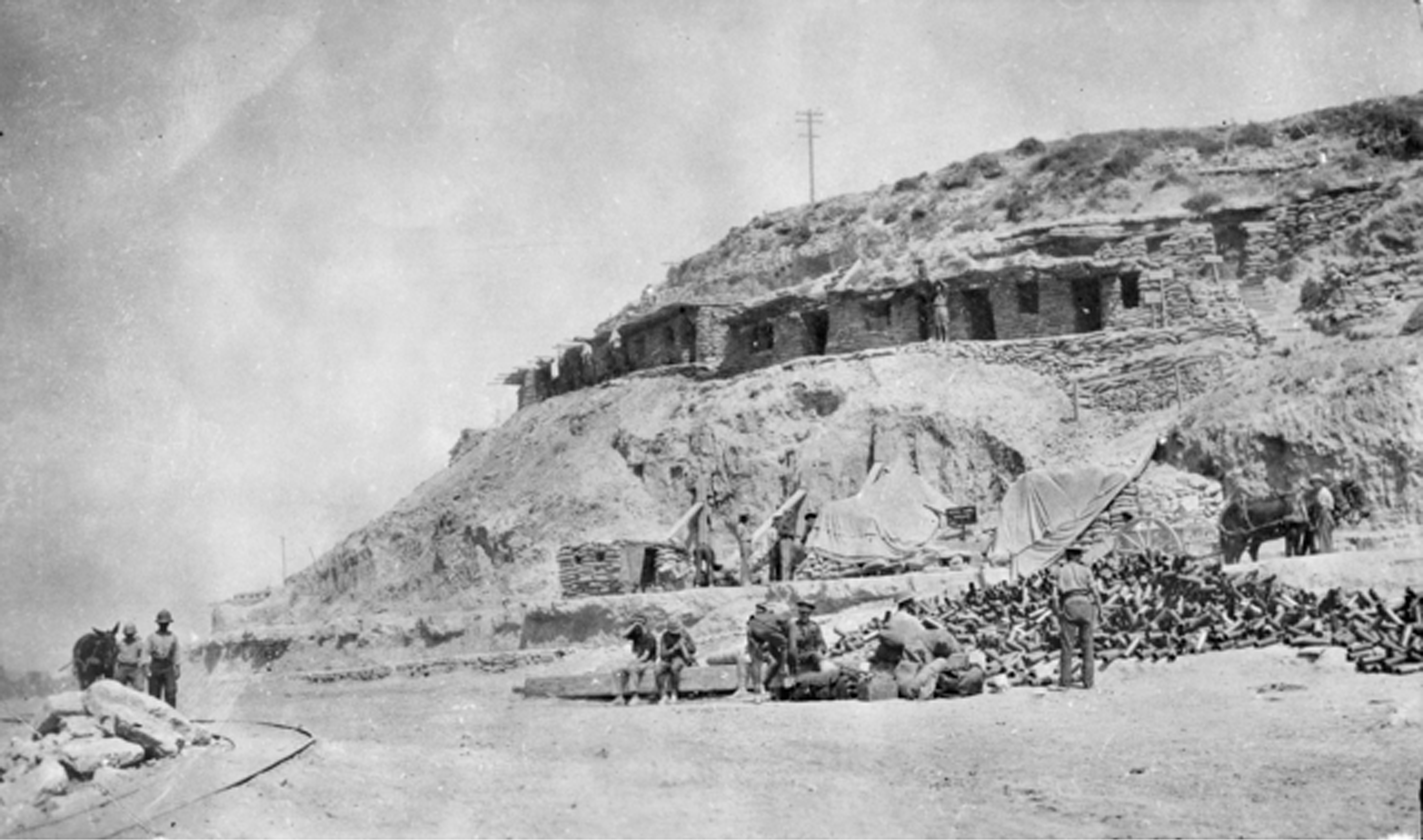
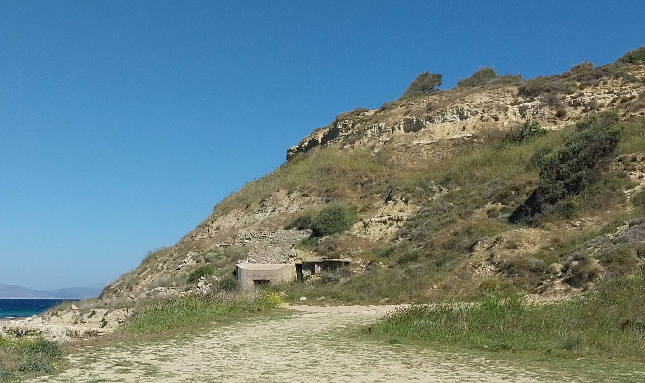
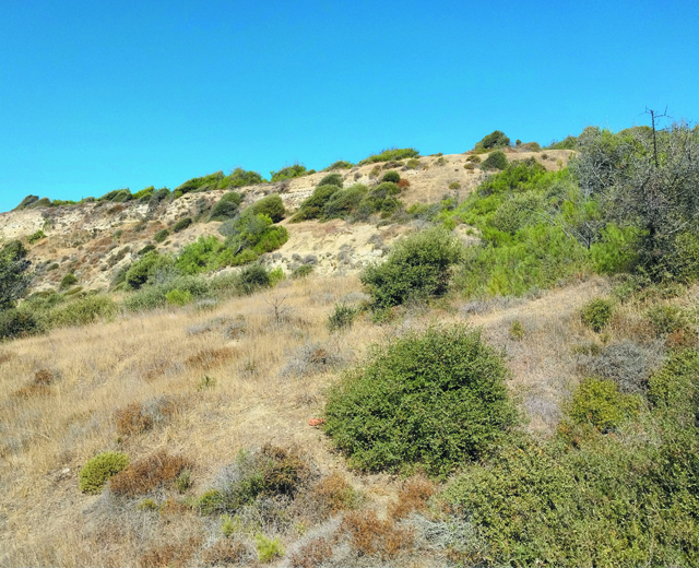
İlk sırada yer alan fotoğraflar koyun yaklaşık kuzeybatı ucunu göstermektedir. Sahilin neredeyse tamamı bu fotoğrafın arkasındadır. Fotoğrafta görülen tepe, koya inen yolun sonunda, sağdadır. Tarihi fotoğraf 1916 ocağında, İşgal Kuvvetleri’nin tahliyesi esnasında çekilmiştir. Günümüz fotoğrafı ise Mayıs 2025 tarihine aittir. Tarihi fotoğrafta görülen barınma alanları günümüze ulaşamamıştır.
The photographs in the first row show the approximate northwestern end of the cove. Almost the entire beach lies behind the viewpoint of this photograph. The hill visible in the image is located on the right at the end of the road descending into the cove. The historical photograph was taken in January 1916 during the evacuation of the Occupying Forces. The present-day photograph dates from May 2025. The shelter areas visible in the historical photograph have not survived to the present day.
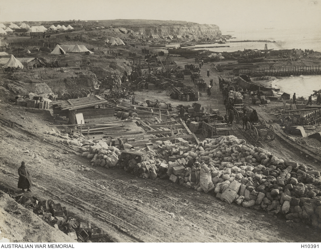
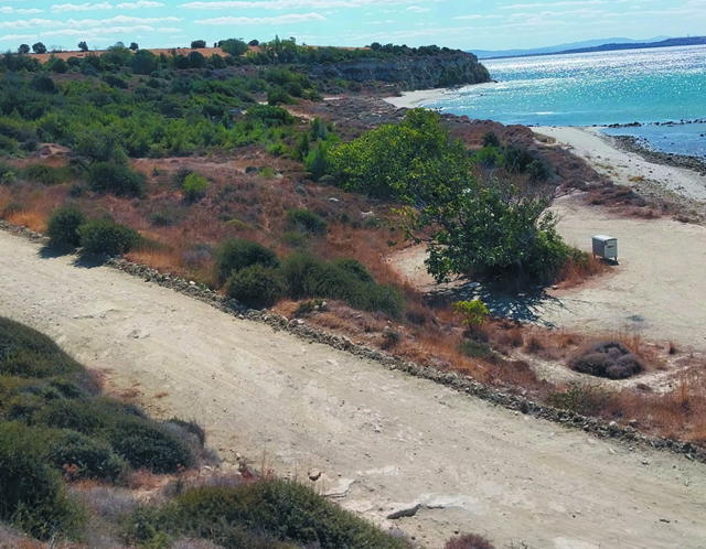
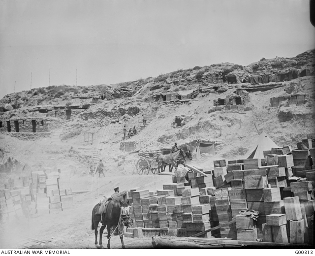
İkinci sıradaki fotoğraflar ise, ilk fotoğraflarda görülen tepeden çekilmiştir. Plajın neredeyse tamamı kadrajdadır. 1916 yılına ait tarihi fotoğraf daha yüksek bir konumdan çekilmiştir. Fotoğraflardan tarihi olan 1916, güncel olan Mayıs 2025 tarihlidir.
The photographs in the second row were taken from the hill seen in the first set of photographs. Nearly the entire beach is within the frame. The historical photograph dates to 1916, while the present-day photograph was taken in May 2025.
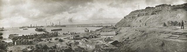
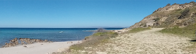
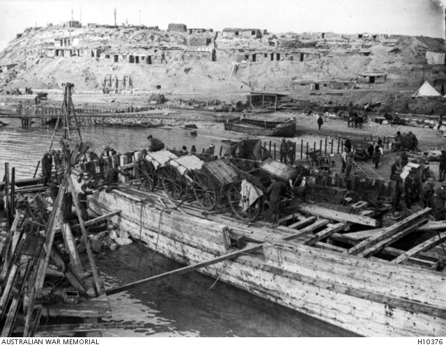
Koyun 1915 yılında çekilmiş panaromik bir fotoğrafı. İskele kalıntıları günümüz (Mayıs 2025) fotoğrafında net bir şekilde görülebilmektedir.
A panoramic photograph of the cove taken in 1915. The remains of the pier can be clearly seen in the present-day photograph (May 2025).
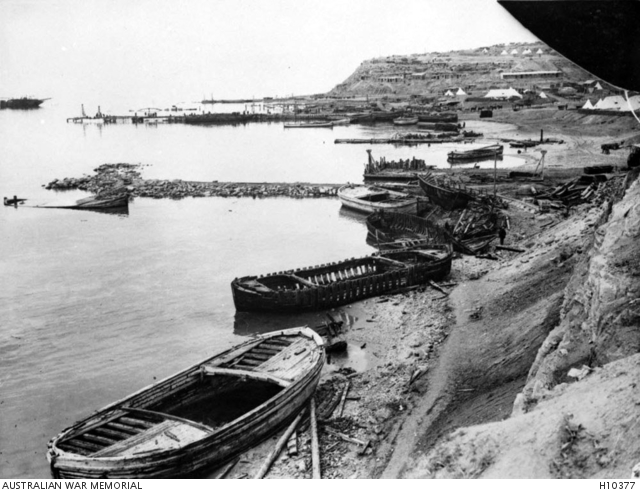
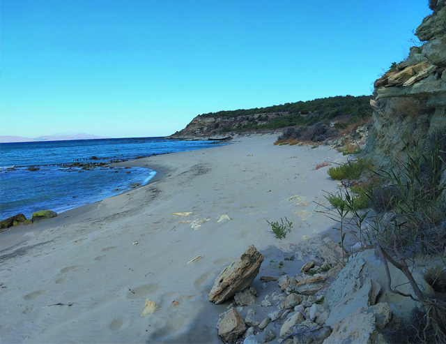
1915 yılında çekilen fotoğraf, ilk sıradaki fotoğraflarda belirtilen tepenin hemen yan tarafını, bu tepede bulunan siperler ve sahildeki yığınaklarla beraber göstermektedir. Güncel fotoğraf Eylül 2025 tarihinde çekilmiştir.
The photograph taken in 1915 shows the area immediately adjacent to the hill mentioned in the first row of photographs, together with the trenches on this hill and the concentrations on the beach. The present-day photograph was taken in September 2025.
Tarihi fotoğraf 1915 yılında, sahilde bulunan iskelelerden birinden çekilmiştir. Bugün iskele yerinde olmadığı için, Eylül 2025'de aynı olmasa da benzer bir açıdan aşağıdaki fotoğraf çekilmiştir.
The historical photograph was taken in 1915 from one of the piers on the beach. As the pier no longer exists today, the photograph below was taken in September 2025 from a similar, though not identical, angle.
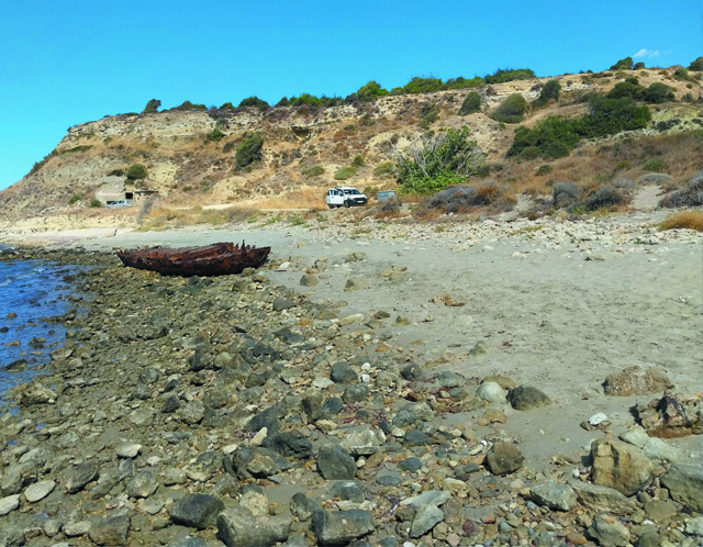
Son karşılaştırmalı fotoğraf bu kez sahilin diğer (yaklaşık güneydoğu) yönünden çekilmiştir ve neredeyse tüm sahil kesimini göstermektedir. Fotoğrafın çekildiği noktada kumsal bitmekte ve dik bir yamaç başlamaktadır. Tarihi fotoğraf 1915, güncel fotoğraf Eylül 2025 tarihlidir.
The final comparative photograph was taken from the opposite (approximately southeastern) direction of the beach and shows nearly the entire shoreline. At the point where the photograph was taken, the sandy beach ends and a steep slope begins. The historical photograph dates to 1915, while the present-day photograph was taken in September 2025.