Arıburnu
Arıburnu
Arıburnu, Gelibolu Yarımadası'nın batı kıyısında (Ege Denizi kıyısında) ve Eceabat ilçe merkezinin kuzeybatısında yer alan küçük bir burundur.
Güneyinde Anzak Koyu, Küçük Arıburnu ve Brighton Beach; kuzeyinde Kuzey Plajı, Büyükanafarta ovası ve Suvla Koyu yer alır.
Günümüzde burnun tam üzerinde (Anzak) Ari Burnu Mezarlığı bulunur.
Ariburnu
Ariburnu
Ariburnu is a small headland on the western shore of the Gallipoli Peninsula (along the Aegean Sea), northwest of the town center of Eceabat.
To its south lie Anzac Cove, Little Arıburnu, and Brighton Beach; to its north are North Beach, the Büyükanafarta Plain, and Suvla Bay.
Today, the ANZAC Ari Burnu Cemetery stands directly on the headland.
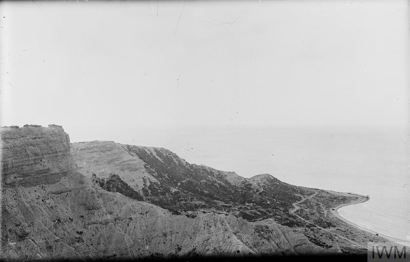
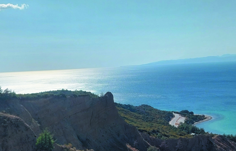
İlk sırada, Arıburnu'nun Yükseksırt'tan çekilmiş fotoğrafları yer alıyor. Tarihi fotoğraf (url-1) eylül 1919 tarihinde, günümüz fotoğrafı ise eylül 2025 tarihinde çekilmiştir.
Fotoğrafın solunda, işgal kuvvetlerinin Sfenks olarak adlandırdıkları yapının üstten görünümü yer almaktadır. Jeolojik ve meteorolojik etkenler nedeniyle bu şekli alan tepenin sahilden görünümü, Anzak askerleri tarafından Mısır sfenkslerine benzetildiği için tepeye bu ad verilmiştir.
The first set shows photographs of Arıburnu taken from Russell's Top. The historical photograph (url-1) was taken in September 1919, while the present-day photograph was taken in September 2025.
On the left side of the photograph is a top view of the formation that the invading forces referred to as the “Sphinx.” This hill, shaped over time by geological and meteorological factors, was likened by the ANZAC soldiers to the sphinxes of Egypt when seen from the shore, hence the name.
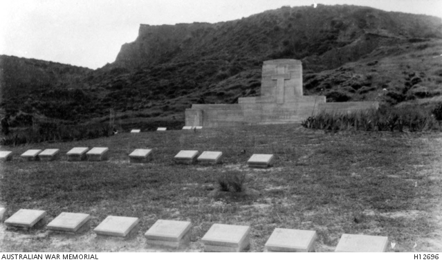
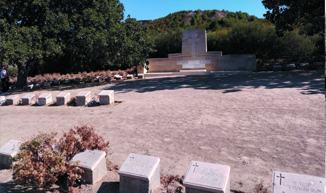
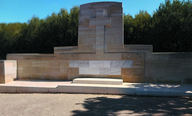
İkinci sıradaki fotoğraflar bugün Arıburnu'nun üzerinde bulunan Ari Burnu Cemetery (Arıburnu Mezarlığı) adlı ANCAZ mezarlığını ve mezarlık anıtını göstermektedir.
The second set of photographs shows the ANZAC cemetery and its memorial, known as Ari Burnu Cemetery, which stands today on the headland of Arıburnu.
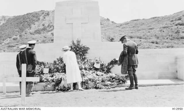
Çıkarmanın sekizinci yıldönümünde (25 Nisan 1923) Arıburnu Anzak mezarlığındaki anıta çelenk koyan bir asker eşi. (url-2)
Gelibolu Yarımadası ve Çanakkale, Osmanlı Devleti'nin başka önemli merkezleri gibi Mondros Mütarekesi’nden (30 Ekim 1918) sonra İtilaf Devletleri tarafından işgal edilmişti. 24 Temmuz 1923'te imzalanan Lozan Barış Antlaşması gereğince, işgal kuvvetleri Ekim 1923’te Çanakkale ve Gelibolu’dan çekildi. Bu nedenle, tarihi fotoğrafın çekildiği 25 Nisan 1923 tarihi itibariyle Gelibolu henüz işgal altındadır. Yine bu tarih itibariyle Türk Milli Mücadelesi'nin 30 Ağustos 1923 Başkomutanlık Meydan Muharebesi ile zafere ulaşmasının üzerinden sekiz ay geçmiştir ve üç ay sonra Lozan Barış Antlaşması imzalanacak, altı ay sonra ise Türkiye Cumhuriyeti Devleti resmen kurulacaktır.
On the eighth anniversary of the landing (25 April 1923), the wife of a soldier is seen laying a wreath at the memorial in the Arıburnu ANZAC Cemetery. (url-2)
Like other key centers of the Ottoman Empire, the Gallipoli Peninsula and Çanakkale came under Allied occupation following the Armistice of Mudros (30 October 1918). In accordance with the Treaty of Lausanne, signed on 24 July 1923, the occupying forces withdrew from Çanakkale and Gallipoli in October 1923. Thus, on 25 April 1923—the date of this historical photograph—Gallipoli was still under occupation. At that time, eight months had passed since the victory of the Turkish National Struggle at the Field Battle of the Commander-in-Chief (30 August 1922). Three months later, the Treaty of Lausanne would be signed, and six months later, the Republic of Turkey would be officially proclaimed.
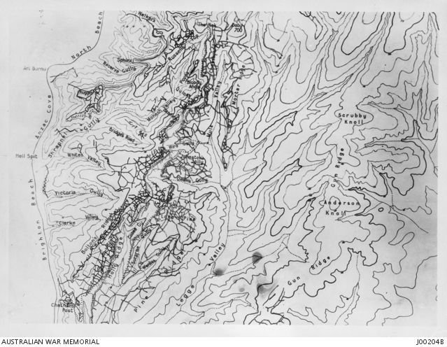
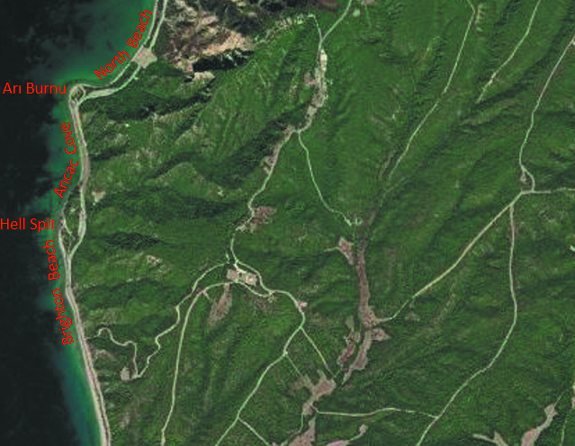
"Brighton Sahili, Anzak Koyu ve Kuzey Plajı’nı gösteren Gelibolu haritası. Bu kopya, Türk Harbiye Nezareti tarafından sağlanan 1:5000 ölçekli bir dizi haritadan derlenmiştir. Siperler, İngilizlerin Yarımada’dan tahliye tarihine göre düzeltilmiştir." (url-3) Harita, günümüz uydu haritası (url-4) ile karşılaştırılmaktadır.
"Map of Gallipoli showing Brighton Beach, Anzac Cove and North Beach. This tracing is compiled from a series of 1:5000 maps supplied by the Turkish War Office. Trenches are corrected to date of the British evacuation from the Peninsula." (url-3) The map is compared with the present-day satellite map (url-4).
Kaynaklar
url-1: https://www.iwm.org.uk/collections/item/object/205249011 © Image: IWM (Q 13885) Erişim Tarihi: 27.09.2025
url-2: https://www.awm.gov.au/collection/H12950 Erişim Tarihi: 27.09.2025
url-3: https://www.awm.gov.au/collection/C1721 Erişim Tarihi: 27.09.2025
url-4: Uydu haritası https://sentinels.copernicus.eu sitesinden alınmıştır. Erişim Tarihi: 27.09.2025. Yer isimleri tarafımdan yazılmıştır.